
Prognostic Charts
Prognostic charts, particularly those extending out to 120 hours (5 days), offer a glimpse into the atmospheric future, revealing the intricate dance of pressure systems, fronts, and air masses that dictate our weather. By analyzing these elements over a 5-day period, you can gain a valuable understanding of how weather patterns are expected to evolve.
Join our weather forums to connect with fellow enthusiasts!
0 – 120 hour Prognostic Charts
Quick Links: Analysis Centre > Surface Analysis > Upper Air Analysis > Prognostic Charts
)
)
)
)
)
)
)
)
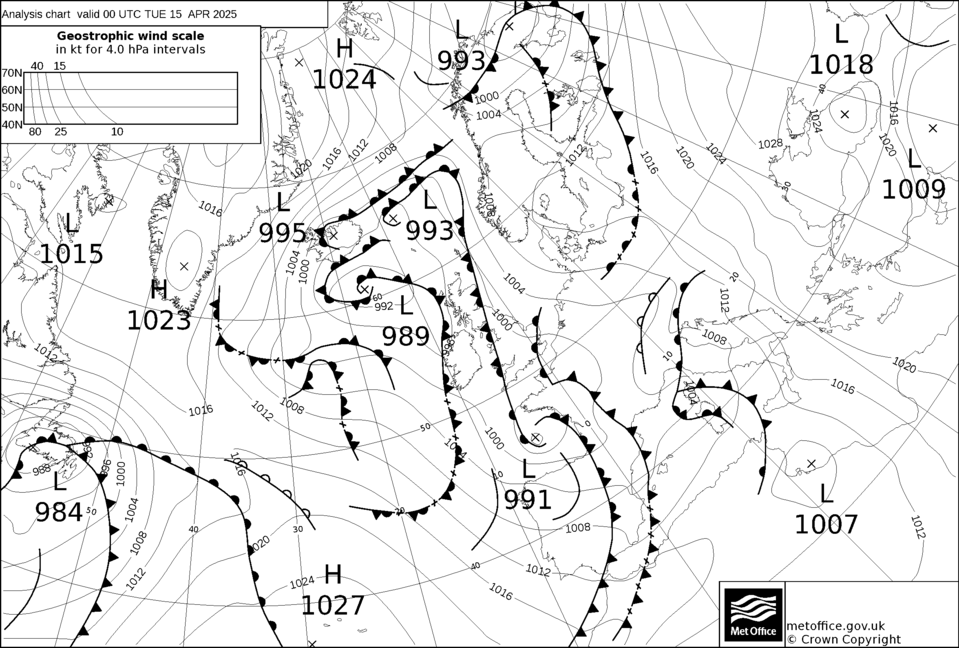
Prognostic weather charts showing isobars, weather fronts and 1000-500mb thicknesses are provided up to 120 hours ahead for Europe and the North Atlantic. This shows a useful analysis of current and forecast conditions with fronts at the surface level.
Data provided courtesy of Wetterzentrale and UKMO
Essential Features and Useful Links
Across 36 European nations, a sophisticated and dynamic weather warning and alert system is working tirelessly to keep the public and authorities informed about severe weather conditions. This live and interactive system acts as a vital lifeline, providing crucial, up-to-the-minute information to help individuals and communities prepare for and navigate potentially dangerous weather events.
Are you passionate about the weather? Do you find yourself constantly checking weather forecasts, tracking storms, and marveling at the beauty of various weather phenomena? If so, you’re not alone. There are thousands of individuals worldwide who share your enthusiasm for all things meteorological. That’s why we’ve created community forums specifically for weather enthusiasts like you!
Whether it’s a dramatic thunderstorm rolling in, a serene sunset painting the sky with vibrant hues, or the playful antics of local wildlife, we want to see the world through your lens. This is your chance to showcase your unique perspective, inspire others with the beauty you’ve captured, and connect with fellow photography enthusiasts.
Whether you’re curious about cloud types, thunderstorm formation, or how forecast models work, our forums are designed for folks at every level. Ask about the basics—like why the sky is blue—or dig into advanced topics such as interpreting radar images or reading soundings. Curiosity is the first step to understanding.

Some data sources (with thanks) provided by: Environment Canada, UK Met Office, EUMETSAT, UCAR & UQAM