danP
New member
There seems to be a bit more consistency in the forecast models regarding some changes to the stubborn pattern across Europe.
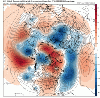
The pattern across Europe for the next fortnight will be upper level troughing (500hpa) / negative height anomalies across Northern Europe and 500hpa ridging / positive height anomalies across the south of Europe for the next two weeks.
This mostly zonal (which is our more typical) pattern should bring normal to above normal temperatures across much of Europe with normal to below normal temperatures mostly limited to Scandinavia and the Baltics due to low 500hpa heights the next two weeks, this could potentially see out the month.
It should bring some much needed relief for the Iberian peninsula and northwest Africa as a more settled regime comes around.
Just my thoughts everyone")
The pattern across Europe for the next fortnight will be upper level troughing (500hpa) / negative height anomalies across Northern Europe and 500hpa ridging / positive height anomalies across the south of Europe for the next two weeks.
This mostly zonal (which is our more typical) pattern should bring normal to above normal temperatures across much of Europe with normal to below normal temperatures mostly limited to Scandinavia and the Baltics due to low 500hpa heights the next two weeks, this could potentially see out the month.
It should bring some much needed relief for the Iberian peninsula and northwest Africa as a more settled regime comes around.
Just my thoughts everyone
Attachments
Last edited: