Nor'easter later this weekend

iceman

New member
Joined
Jan 16, 2026
Messages
6
Location
Petrinja, Croatia
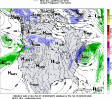
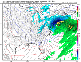
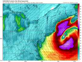
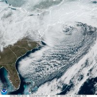
One system for Saturday, and then some of the models bring a system for the northeast USA and Atlantic Canada that bombs out on Monday morning.

Could be a very intense weekend for the northeastern US and Atlantic Canada. There is a (very) cold pool filling in behind these systems potentially creating a major weather event.
 

Attachments

  • PT_PN_108_0000.gif
    PT_PN_108_0000.gif
    217.7 KB · Views: 0
Monday/Tuesday looks to be the big one. We might be talking one of the most intense winter storms the eastern seaboard has seen in years. The pressure completely bombs out, modeled pressure dropping to 966mbn (gfs) near Cape Hatteras. The main sticking point is the track of the system and will it move slight further offshore following the upper level trough or be slower moving and hug closer to the coast.

We could be talking blizzard conditions from Virginia all the way up into the Atlantic Canadian provinces with considerable snow accumulations.
 

Attachments

  • gfs_mslp_pcpn_frzn_eus_9.png
    gfs_mslp_pcpn_frzn_eus_9.png
    249.4 KB · Views: 0
The GFS has solid 14-18" 24 hour snow accumulation by 06z Tuesday for the Massachusetts/Rhode Island area, with a 12-14" area up toward the Maritimes provices of Canada. So we are talking, 20 to 50cm from North Carolina all the way up to Nova Scotia and New Brunswick. I think we'll see higher accumulations locally. The NAM hi-res shows a very intense band of snow to the northwest of the centre tonight and tomorrow for the eastern seaboard.

Almost certainly looking at a bombogenesis event as this storm bottoms out 24mb (at least) in 24 hours.
 
Last edited:
A whole host of warnings issued for much of the east coast, from blizzard to storm warnings. Environment Canada has issued advisories for the Maritimes, I can they are solid for a bit more confidence in the models and imagery before issuing warnings. Some of the models show the central pressure climbing as the storm approaches the Maritimes, perhaps giving reason for it to lose some intensity later tomorrow.
 
Fascinating from a weather point of view. Watching this develop from a frontal wave into an itense low with an eye-like feature forming. It has almost everything weather could throw.

Thunderstorms, gale-force winds, heavy bands of snow, thundersnow, huge temperature gradient between the warm and cold sector and even potential for a sting jet.

The radar loops shows a very intense band of snow with lightning returns in the NYC area and up toward Cape Cod.

It's a slow moving storm, expect accumulations to pile up.
 

Attachments

  • FB_IMG_1771826267379.jpg
    FB_IMG_1771826267379.jpg
    21.9 KB · Views: 0
The winds look like packing a punch later today and overnight. Coastal region from Cape Cod, Maine and into the Maritimes very exposed to strong northeasterlies.

With all the snow talk, the gales are being forgotten where we could be talking 70mph+ damaging gusts.

Central pressure has dropped to 971mb.
 

Attachments

  • gem_mslp_wind_neus_4.png
    gem_mslp_wind_neus_4.png
    246 KB · Views: 0
Current central pressure sitting at 966mb, likely we are getting close to the storm bottoming out. Having lived in the Maritimes and seeing my fair share of nor'easters, I would not be surprised to see accumulation totals be considerably lower in Canada than what the US has seen. Quite often, dry slots become more pronounced as these systems push into the Gulf of Maine. It's also expected to pick up motion as the inverted upper level trough sweeps up the surface low, the bands of precipitation tend move through quicker.

Fascinating to watch.

Love the latest satellite image from GOES east, the frontal features and the area of frontogenesis producing the heavy snow through Boston and Cape Cod area showing up well.

Ps. Light snow has started falling in southern Nova Scotia and New Brunswick.
 

Attachments

  • 20260541601_GOES19-ABI-eus-GEOCOLOR-1000x1000.jpg
    20260541601_GOES19-ABI-eus-GEOCOLOR-1000x1000.jpg
    332.5 KB · Views: 1
Some snow totals from NWS. We're in the 90cm range here 😱 
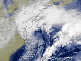
Rhode Island got buried!

01:01 am CEST - 2/24/2026TF Green AP, RI37.9
09:10 pm CEST - 2/23/20261 SE Warwick, RI36.2
01:40 am CEST - 2/24/20263 W North Kingstown, RI36
10:21 pm CEST - 2/23/20261 S Providence, RI36
02:25 am CEST - 2/24/20261 NW Warren, RI35.5
08:33 pm CEST - 2/23/2026North Kingstown,35
03:00 am CEST - 2/24/20261 SW Newport AP, RI34
 
I live in Nova Scotia and the snow totals were average here for a nor'easter. We certainly did not see the accumulations they got Stateside, but it was a wild night with whiteout conditions for most of the night and early this morning.

Here in Springhill I measured a depth of 26 to 30cm fresh snow, taking multiple measurements with a yardstick and subtracting what was already on the ground. It's difficult to measure as the snow was quite wet and compacted down, so some level of estimation is there. I think down on the south shore of Nova Scotia, I heard reports closer to 40cm.

I have posted some photos in the gallery.

Environment Canada may or may not post a summary with snow depths of the storm. They are not usually so public as the NWS on post-storm reports.
 
Back
Top