Storm Goretti

maritimesbob

New member
Staff member
Joined
Jan 7, 2025
Messages
126
Location
Gouda, Netherlands
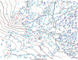
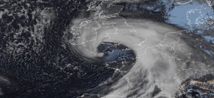
Storm Goretti as named by the French weather office is forecast to impact the southern UK, northern France and the low countries over the next 48 hours, bringing gales to the south of the UK, Brittany and Normandy, and potentially significant snow to the west midlands and Wales (UK).

For northern France, likely gales or storm force winds tomorrow evening and through Thursday night. Due to the forecasted track of the system, the southern coast of the UK, France and the low countries (Netherlands, Belgium) will draw up mild air resulting in rain Thursday night, on the northern flank of the low it taps into cold air bringing snow and mixed precipitation to central and western England.

I am sorry for a quick post on this, I will try and update with more detail later. Feel free to add to this and keep all impacts of this storm to this thread.
 

Attachments

  • Screenshot 2026-01-07 at 18-16-48 UK weather warnings - Met Office.png
    Screenshot 2026-01-07 at 18-16-48 UK weather warnings - Met Office.png
    319.5 KB · Views: 0
  • BRAEU_48.png
    BRAEU_48.png
    195.6 KB · Views: 0
Folks on the southern coast of England, Brittany, Normandy and through the channel need to be aware, the prognostics call for a period of very strong winds Thursday evening and early Friday morning. We could be looking at gusts to 85mph (135+kph) in these regions.
 

Attachments

  • GZ_D5_PN_036_0000.gif
    GZ_D5_PN_036_0000.gif
    121.4 KB · Views: 0
I might dare to add, we could be close to a weather bomb with this thing. The CMC shows it deepening very rapidly and meeting that criteria. Expecting some major winds down here in Cornwall.
 
The snow threat for central England and Wales appears to be receding. Looks like primarly a wind and rain event. Coast of north France and the channel islands look to be hit with a few hours of severe gales this evening.
 
The warm front will passage through most of the Netherlands bringing rain, perhaps starting as mixed precip for an hour. The far north of the Netherlands looks likely to remain on the cold side of the low, more chance of staying as snow and mixed precip. As the low exits, all of the Netherlands taps into the colder temperatures, it will transition to light snow and snow showers Friday night and Saturday.
 
Center is southwest of Ireland. She has moved from a baroclinic leaf to developing the distinct comma shape as this deepens rapidly.
 

Attachments

  • Screenshot_20260108_125310_Dolphin.jpg
    Screenshot_20260108_125310_Dolphin.jpg
    422.8 KB · Views: 0
Latest barometric pressure is at 985mb, expecting that to fall in the next few hours. Quite gusty here, expecting peak winds around 8pm.
 

Attachments

  • 2026010812_eur.gif
    2026010812_eur.gif
    200.6 KB · Views: 0
I think we'll be under a red warning soon, batten down the hatches time!
 

Attachments

  • FB_IMG_1767880479886.jpg
    FB_IMG_1767880479886.jpg
    100.8 KB · Views: 0
Take care Dan, you'll be in for a wild couple of hours. It's made bomb criteria, central pressure is at 972mb and dropping. Not seen isobars packed so tight as this for years o_O
 
Incredible imagery of the storm on latest satellite. Show's a potential sting jet, no wonder the UKMO has issued a red warning.
 

Attachments

  • sat1.jpg
    sat1.jpg
    329.2 KB · Views: 0
The power has been on and off here, but I can see toward Marazion and it looks out over the bay. I've been out with my handheld anemometer, measuring gusts, highest 86mph but take that with caution. Not sure how long I can be online for. Britishwxwatcher, I can concur as my ecowitt barometer is showing 970mb, sometimes 968mb.
 
Stay safe folks. I have family on Jersey and they said it's blowing a hooley there. Nothing like this down in Gib! Places likes Roscoff and along the Normandy coast are going to be hit hard.
 
I live in Normandy, I recorded a gust of 143kmh just outside of Caen. I will post some recordings from across Brittany and Normandy later. I network between weather stations here.
 
Barfleur - Gatteville-le-Phare : 213 km/h
Barneville – Carteret : 182 km/h
Saint-Vaast-la-Hougue : 177 km/h
Cap de la Hague : 157 km/h
Fécamp : 157 km/h
Vigiu Du Humet : 152 km/h

From across the Contentin Peninsula, Normandy
 
Barfleur - Gatteville-le-Phare : 213 km/h
Barneville – Carteret : 182 km/h
Saint-Vaast-la-Hougue : 177 km/h
Cap de la Hague : 157 km/h
Fécamp : 157 km/h
Vigiu Du Humet : 152 km/h

From across the Contentin Peninsula, Normandy
Incredible gusts. The low collapsed very quickly once it tracked across the southern england coast,
 
Back
Top