danP
New member
The medium range outlook if looking fairly grim for much of western Europe, particularly those countries exposed to the Atlantic. Quite unusual for the time of year, a lot of the weather is being drive to the southwest of Europe and northwest Africa. We can partly blame the intense cold pool over north America and the collapse of the polar vortex for creating such a highly amplified pattern over western Europe.
This disruption of the polar vortex is causing the jet stream to buckle, which can pull frigid air further south into mid latitudes, including parts of Europe where intense cold has sat over eastern-most Europe and parts of Scandinavia for several weeks now.
I see more intense rains for Iberia, Morocco and into the western Mediterranean, and always the chance of some deep cyclogenesis bringing possible severe wind events anywhere exposed to the Atlantic. It does not bode well for the much vaunted easterly Siberian intrusion, that is of course always being teased in the long term model forecasts!
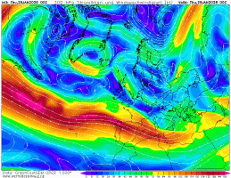
It simply looks like more of the same into early February as we have stubborn blocking to the east. I've attached an animation of the progged 300mb jet stream for the next 7 days, it gives a guide for the weather. Think of the jet stream as a path for the low pressure systems to follow.
This disruption of the polar vortex is causing the jet stream to buckle, which can pull frigid air further south into mid latitudes, including parts of Europe where intense cold has sat over eastern-most Europe and parts of Scandinavia for several weeks now.
I see more intense rains for Iberia, Morocco and into the western Mediterranean, and always the chance of some deep cyclogenesis bringing possible severe wind events anywhere exposed to the Atlantic. It does not bode well for the much vaunted easterly Siberian intrusion, that is of course always being teased in the long term model forecasts!
It simply looks like more of the same into early February as we have stubborn blocking to the east. I've attached an animation of the progged 300mb jet stream for the next 7 days, it gives a guide for the weather. Think of the jet stream as a path for the low pressure systems to follow.